What would happen if a forest fire threatened Planas del Rey? How would residents be warned? Would they have to evacuate or remain in their homes? Which roads should they use? Would firefighters have access to enough water?
Several official documents now provide some answers: the Planas del Rey Self-Protection Plan, drawn up in 2006 and officially approved in 2007; the Municipal Forest Fire Prevention Plan, approved in 2023; and Pratdip’s DUPROCIM*, definitively approved in 2022 and updated in October 2024.
These documents set out a genuine emergency response framework. However, comparing them also reveals significant differences between the instructions issued in 2006 and those in force in 2024. Above all, it shows that some of the equipment and procedures described in the plans need to be regularly checked and adapted to the actual situation on the ground.
*DUPROCIM — the Single Municipal Civil Protection Document — sets out how the municipality should respond to the main risks it faces, including fires, floods, strong winds, accidents and other emergencies.
Update of 10 September 2026: following the publication of this article, Pratdip Town Council provided us with additional information. This information has been incorporated below, with its source clearly indicated.
A risk officially classified as very high
The DUPROCIM states that more than 85% of the municipality of Pratdip consists of forest land. It classifies the forest fire risk as very high and the municipality’s vulnerability as high.
Planas lies directly alongside wooded areas, between the Dòvia ravine and the River Llastres. As early as 2006, the plan highlighted the continuous vegetation extending between the forest, private plots and homes.
It also drew attention to the steep slopes in certain areas, particularly around Carrer Magnolia, as well as to the wind, dry vegetation and large number of pine trees.
The 2024 DUPROCIM records 334 residents in Planas and estimates that the population can rise to around 1,000 during the summer. This seasonal increase makes the organisation of warnings and any possible evacuation particularly important.
The Town Council explains that these seasonal variations are known and taken into account in municipal planning. Among other factors, the emergency services use estimates based on the number of homes when preparing possible response, evacuation or shelter-in-place operations.
In the event of a fire: evacuate or remain at home?
A comparison of the documents shows that the general guidance has changed.
In 2006, Planas was classified as a type B residential development, meaning an area that did not meet all the required fire protection conditions. The plan did not provide for residents to shelter in place and envisaged self-evacuation as soon as a forest fire was confirmed.
The 2024 DUPROCIM takes a different approach. It provides for an assessment of whether residents should remain indoors or be evacuated, stating:
“In general, sheltering in place is the best option if the house provides adequate protection, although provision must be made for the possible evacuation of locations that do not offer such protection.”
The decision will therefore depend on the location of the fire, the direction of the wind, the smoke, road conditions and the level of protection offered by individual homes.
The Town Council explains that, if a forest fire affects the population, an Advanced Command Centre coordinates the emergency services and firefighters. Decisions on evacuation or sheltering in place are then made according to how the situation develops.
If you discover a fire, call 112 immediately. Residents should then follow the instructions issued by the firefighters and the authorities rather than deciding independently to leave by road.
Two exits and two assembly points
Planas has two main road access points:
- to the north, the road connecting Avinguda de Pratdip with the T-310;
- to the south, the road connecting Carrer Dàlia with the T-318.
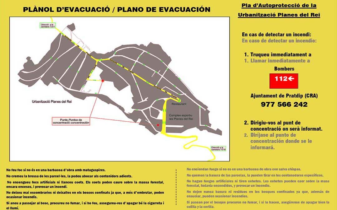
The 2006 plan also identified Avinguda de Pratdip, Carrer Clavell and Carrer Tulipa as internal evacuation routes. It designated two assembly points:
- the Planas del Rey sports area;
- the undeveloped land between Carrer Tulipa and Carrer Orquídea.
The document recommended reaching these assembly points on foot whenever possible and reserving vehicles for people requiring assistance.
However, it also warned of the risk of congestion on the roads leading out of Planas because of the steep gradients and sharp bends, particularly on the route towards the T-310.
To the best of our knowledge, there is no continuous network of forest tracks allowing fire engines to travel around Planas. The emergency services must therefore rely mainly on the two access roads and the streets within the residential development.
The Town Council confirms that the two assembly points identified in the 2006 plan remain valid.
How would residents be warned?
The 2006 plan provided for residents to be alerted through the residential development’s fixed public-address system. If this system was not working, warnings were to be delivered directly to individual homes.
The 2023 municipal plan lists several methods:
- loudspeakers located in the streets of Pratdip, Planas and Santa Marina;
- landline and mobile phones;
- municipal vehicles equipped with portable public-address systems;
- the Town Council’s website;
- the tourist information office.
The Town Council also currently uses the eAgora application to publish announcements and urgent alerts.
These methods are supplemented by the ES-Alert system, which enables the authorities to send emergency warnings directly to mobile phones located within the affected area.
Regarding the fixed loudspeakers, the Town Council explains that their operation cannot be guaranteed because Planas does not have a public electricity network. It also confirms that the public-address system does not cover the entire residential development.
New fire hydrants in the lower part of Planas
In 2006, there were no compliant fire hydrants available for use by firefighters. The plan listed 17 underground irrigation outlets but stated that they did not provide sufficient pressure to be fully operational.
Their operation also depended on a pump that had to be activated from the maintenance building. A power cut or pumping failure could therefore prevent them from being used.
The 2024 DUPROCIM lists 15 installations in Planas under references H18 and H26 to H39. However, a note specifies that only the installations marked with an asterisk in the municipal table actually function as fire hydrants. All the others are considered ordinary irrigation outlets whose flow rate and pressure cannot be guaranteed.
None of the 15 installations listed in Planas is marked with this asterisk.
At the time it was drawn up, the 2024 municipal document therefore did not confirm the existence of any fire hydrant capable of providing firefighters with the necessary flow rate and pressure.
However, the Town Council states that, since the DUPROCIM was prepared, new operational fire hydrants have been installed in the lower part of Planas, around the sports area, as part of improvements to the water network.
Water reserves that are now more clearly identified
The 2006 plan listed the public swimming pool, whose capacity was then estimated at 600 m³, several reservoirs within the residential development and various private swimming pools that could be used if necessary.
In 2017, a dedicated fire-fighting water reservoir with a stated capacity of 200,000 litres was also presented for Planas.
The 2023 prevention plan refers to a “water basin or swimming pool” in Planas with a capacity of 450 m³. It is described as accessible to helicopters, but not intended for public use and not included in the main network of fire-fighting water points.
The Town Council clarifies that this 450 m³ water point is the municipal swimming pool. Since 2023, it has been kept full and available to the fire services.
Public and private swimming pools can also be used to supply fire engines with water.
Regarding the reservoir in the northern part of Planas, the Town Council confirms that it has pipes and road access allowing the fire services to draw water from it. However, its current water level has not been specified.
Lastly, the Town Council states that the football pitch opposite the Casal may occasionally be used as a helicopter landing area. It is not, however, a specially equipped helipad.
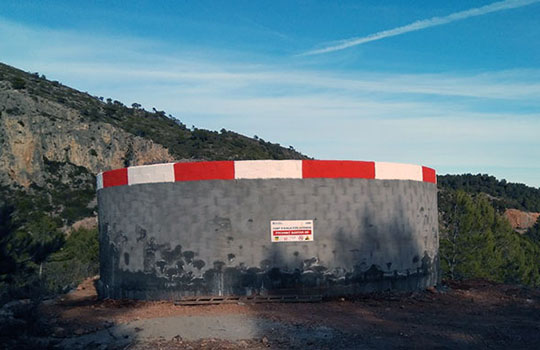
The 200,000-litre water reservoir intended for firefighting, photographed in November 2017. The Town Council confirms that it has pipes and access allowing firefighters to draw water from it.
A protective strip has been cleared, but maintenance is continuing
A perimeter firebreak is an area at least 25 metres wide in which dry vegetation must be removed and trees thinned and pruned.
In 2006, this protective strip had not been created around the entire perimeter of Planas. Only certain areas near the access roads had been treated in 2005, and they already required maintenance.
The 2023 plan stated that complete information was not available on the extent to which the municipality’s perimeter firebreaks had been completed. It estimated that around 20% of those examined had been fully or partially created, including the one around Planas.
The plan also provided for a vegetation reduction area in the Dòvia ravine, alongside the T-310, to slow the spread of a fire and ensure continuity with the protective strips around the residential development.
The Town Council states that the protective strip has now been cleared around the entire perimeter of Planas. Maintenance began in the northern part of the residential development, with work carried out in 2024 and again in June 2026, but it has not yet been completed around the whole perimeter.
This work is based on the Pratdip Municipal Forest Fire Prevention Measures Delimitation Plan, approved in 2016.
Emergency drills still need to be organised
The DUPROCIM provides for at least one municipal civil protection drill every year. A forest fire exercise should test communications, warning systems, shelter-in-place procedures, evacuation, access control and the selection of reception centres.
However, the assessment forms included in the document have not been completed. It is therefore impossible to confirm from them whether such an exercise has already been organised with the participation of Planas residents.
The Town Council states that it is working with the Diputació de Tarragona to implement the planned measures. A phase involving public information, preparation, signage and the planning of emergency drills is due to begin at the end of 2026.
The 2006 plan also provided for the identification of people requiring assistance and for transport to be assigned to them. However, the corresponding list is blank in the publicly available version of the document.
The Town Council explains that it holds up-to-date information on vulnerable people, in coordination with medical and social services. This personal information appears in the confidential version of the DUPROCIM and cannot, of course, be included in the publicly available version.
Technical inspections have begun
At the beginning of September, the Town Council announced that technicians from the Consorci de la Serra de Llaberia would visit Planas to inspect buildings, plots and their surroundings.
The aim is to assess their vulnerability to forest fires and identify the necessary prevention and self-protection measures.
The Town Council confirms that these inspections have now begun. An individual assessment sheet will be prepared for each plot before an overall analysis of the situation in Planas is carried out. The first results should be available within approximately two months.
The Town Council is responsible for work in public spaces and on the protective strips falling within its remit. The maintenance and safety of private plots remain the responsibility of their owners.
What the Town Council has confirmed and what remains unclear
The information provided by the Town Council confirms several important points:
- the two assembly points identified in 2006 remain valid;
- the ES-Alert system can supplement the other warning methods;
- the fixed public-address system does not cover the whole of Planas and its operation cannot be guaranteed;
- new operational fire hydrants have been installed around the sports area;
- the 450 m³ water point is the municipal swimming pool, which has been kept full since 2023;
- the reservoir in the northern part of Planas has pipes and access for fire engines;
- the protective strip has been cleared around the entire perimeter, but its maintenance is continuing;
- the Town Council holds up-to-date confidential information on vulnerable people;
- technical inspections of individual plots have begun.
However, the information provided does not include two practical details: the current water level of the 200,000-litre reservoir and the exact number and detailed location of the new fire hydrants.
The position of Pratdip Town Council
On 10 September, following the initial publication of this article, the Mayor of Pratdip, Sílvia Carrillo, provided us with several clarifications and the following concluding statement. We are reproducing it in full so that the Town Council’s position is presented in its own words.
“At Pratdip Town Council, we are fully aware that forest fires are one of the main risks facing our municipality and that, in an area with extensive forest land, this issue requires constant attention. We do not claim that everything has been resolved or that there are no longer any areas requiring improvement. On the contrary, we consider the protection of the population to be a continuous process of assessment, action and improvement.
The municipality has specific civil protection and fire prevention plans in place, including an updated and officially approved DUPROCIM, the Forest Fire Prevention Plan, the Delimitation Plan and the Planas del Rey Self-Protection Plan. On the basis of these plans, the Town Council has gradually implemented practical measures and continues to work on improving prevention and emergency response. In recent years, work has been carried out to clear and maintain the protective strips, as well as to improve the water network and water supply points. Further measures are also under way to gain a better understanding of the vulnerabilities within the residential areas.
Within this framework, we are currently working closely and intensively with the Consorci de la Serra de Llaberia, the Rural Agents and the fire service to ensure that fire prevention and protection are based on technical criteria and an overall view of the area. The ongoing inspections and assessment of plots in Planas del Rey will make it possible to identify the specific vulnerabilities of each property and determine the necessary information and corrective measures.
This work also involves recognising that protection against forest fires is a shared responsibility. The Town Council is responsible for taking action in municipal spaces and infrastructure, as well as in the protective areas falling within its remit, but property owners also play an essential role in maintaining the safety of their plots. One of our current areas of work is therefore to gain a better understanding of the specific needs of each sector and involve everyone concerned in reducing the risk.
The reality, therefore, is that the municipality has plans in place and is taking action. Pratdip has identified the risk, has planning instruments available and is continually working to improve its prevention and emergency response capabilities. We are aware that there is still work to be done and that some measures can and must be improved, but that is precisely part of the work currently under way.
We cannot claim that the risk does not exist. We must work to ensure that, when it arises, the municipality is as well prepared as possible to deal with it. And that is precisely what we are doing.”
Statement provided in Spanish and translated into English by La Tribune de Planas.
This article may be further updated or corrected if we receive new, precise or up-to-date information.
6/09/2026
La Tribune de Planas
Reference documents
For detailed information on the technical provisions and the planned measures concerning forest fire prevention, protection and risk management, the following three documents are available: